Welcome to C_E RoadSoft!
C_E RoadSoft is a software program for illuminance, luminance and STV calculations that uses web-browser forms for input and output. The RoadSoft calculation uses the roadway surface and calculation grid defined in the RoadSoft form along with the specified luminaire photometric data file and characteristics. The program follows the applicable calculation procedures defined in ANSI/IES RP-8-00, American National Standard Practice for Roadway Lighting and presents results for the illuminance, luminance and Small Target Visibility (STV) methods.
This discussion covers the basic information about using C_E RoadSoft. For additional discussion about calculations and features in C_E RoadSoft, including examples, read more here. For technical discussion about files etc, read more here.

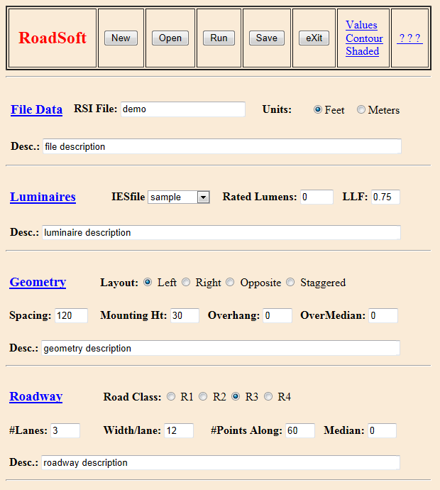
The RoadSoft form provides capabilities for the different parts of input for the RoadSoft calculation. The RoadSoft form enables creating and changing .rsi files, running calculations and viewing results. An examples form is shown to the left. The form includes a title and a set of command buttons concerning the entire file, such as Open or eXit, in the top row. The remainder of the form is input for the file, luminaire, geometry and roadway specifications. The form includes radio buttons (pick one) where suitable as well as a selection box listing available photometric files (other names can also be entered). The other fields are for text entry, with numerical information required as appropriate.
The links shown in the top row lead to numerical or graphical results or help documents (like this one), while those in the rest of the RoadSoft form show the appropriate item in the Terminology document.
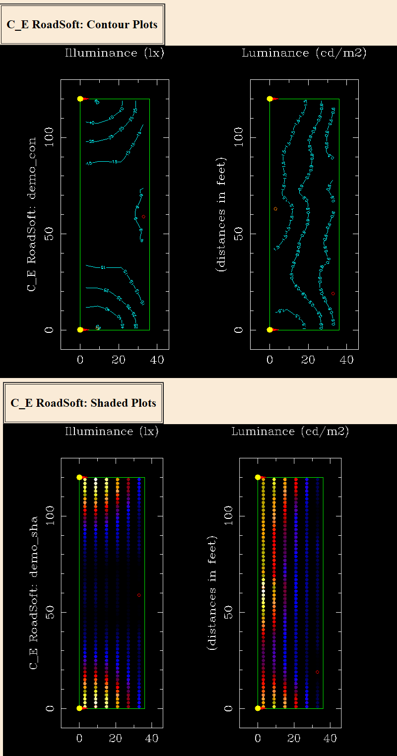
The commands in C_E RoadSoft are shown in the set of buttons and links across the top of the form. The choices of buttons are New, Open, Run, Save and eXit. New and Open change which file is presented and Save writes the currently displayed file contents to the indicated name. No file protection is provided in RoadSoft, so files can/will be overwritten without notice. This applies to files that are saved and also files produced from Run commands. The Run command will first save the current file and then use it as input for running the appropriate software. Save will just save the file without running the software. The eXit command will close the form and proceed to the MDI Software Options. No check for "save changed data" is provided. The remaining commands use links to open new browser windows. The links for Values, Contour and Shaded will show output corresponding to the current file, and examples are shown below. The ? ? ? link leads to additional information such as this document.
For any command button or link, the capitalized letter can be used with Alt as a shortcut e.g. alt-X selects eXit.
The RoadSoft calculation includes the RP-8 methods of illuminance, luminance and STV. Consistent with these calculations, the RoadSoft program includes specification for the roadway surface and values used to establish the calculation grid over the roadway surface. This information is shown on the RoadSoft form, including the units selected and the optional descriptions. The units can be Feet or Meters, and the same units are assumed for the points and the luminaire locations. The Roadway information at the bottom of the form includes the choice of R1, R2, R3 {recommended default} or R4 surface along with the number of lanes, width of each lane, number of grid points along each lane and the distance the grid extends. Together these values describe a regular horizontal grid of points consistent with RP-8. In RoadSoft, the number of lanes times the number of points along must be less than 320 for the calculations to succeed.
The location of a point is specified using <x, y, z> coordinates in a typical arangement with +x considered "eastward", +y "northward", and +z as upward. The grid of calculation points follows the specifications in RP-8. The number of points along the spacing distance ('points along') may be increased above the minimum as discussed in RP-8.
In RoadSoft, the luminaire type is defined based on one photometric file, with additional values that are specified in the form. The file must be in IES format with a copy in the IES photometry directory associated with RoadSoft for a calculation to succeed. In the form there is a list of such files for selection, although a different file name can be entered. To get photometric files into the appropriate directory, use the MDI Files Utility discussed here and available from the MDI Software option page (the first page after sign-in).
The additional luminaire values are rated lumens, LLF (light loss factor) and multiplier. These values can be any positive number. For rated lumens, a value of zero in the RoadSoft file will be replaced for the calculation by the rated lumen value in the photometric file. For light loss focators, the LLF calculator is available through the LLF link. In a RoadSoft calculation, the values for LLF and multiplier will be multiplied together with the rated lumens to determine scaling for the photometric file data.
Luminaires are located in space using conventional <x,y,z> coordinates and units specified on the RoadSoft form, in a pattern set by the roadway geometry specifications. Every luminaires' location is listed in the .rs0 output file and included in the composite Values file (discussed below).
In RoadSoft, the input file specifies only one type of luminaire. Aiming for each individual luminaire is automatically set following the pattern specified (e.g. staggered). Luminaires will be oriented perpendicular to the roadway, and no other aiming is applied. In the .rs0 file, each luminare's orientation is reported using degrees with the "compass rose" definition: "North" = 0 and values increase clockwise. The patterns available in RoadSoft will assign 90 degree orientation to luminaires on the left side of the roadway and 270 degrees for those on the right. No other aiming of the photometric data is provided in RoadSoft.

In the RoadSoft form the Run button in the top row will save the current version of the input file and then run the calculation with that file for input. The software will in turn use the selected photometric file to produce results. The base name for output files is taken automatically from the input file name.
When the calculation is completed, the results links turn red. These links each open a separate browser window to display the chosen output. Values shows a composite text file combining several separate files (which are separately listed in the Files Utility, discussed below). The browser's Save command can be used to save a copy of the composite file.
The results can also be viewed as Contour or Shaded, showing a plan view including only the luminaires adjacent to the calculation grid. All the luminaires are listed in the .rs0 and Values composite files.
There are several additonal software elements available. One is the LLF calculator available through the LLF link. Another is the Files Utility for handling files in the MDI Software system.
The MDI Files Utility can be accessed from the page offering MDI Software options, shown immediately after signing in to the MDI Software system or by using the eXit command in any RoadSoft form. This utility can be used to upload, view and manage files in the MDI Software system. It also provides access to the MDI Library of photometric files.
The MDI Software system includes forms for viewing account information, also available through the MDI Software options page. If the RoadSoft program becomes unavailable, check the account status there.
This brief discussion about RoadSoft is intended to provide an introduction without too much detail. More information is available here.